The following information is from the Environment Agency Website (4/1/2014)
http://watermaps.environment-agency.gov.uk/wiyby/wiyby.aspx?topic=floodmap#x=489392&y=178023&scale=9


See also this article from "The Independent"
http://www.independent.co.uk/news/uk/home-news/flood-warning-why-the-longterm-forecast-for-homeowners-is-so-alarming-9031728.html
_________________________________________________________________________________________
_________________________________________________________________________________________
The following text is that of an email I sent to the Environment Agency and copied to RBWM on 6th January 2014;
Dear Sir/Madam,
I need some urgent clarification about what seems to me to be an error in your website.
This is urgent because the Royal Borough of Windsor and Maidenhead is currently preparing to consult on possible housing developments in the area of the maps shown herein, (consultation starts 10/01/2014 - and if I am correct they are using a flood risk assessment that is lower than actual.
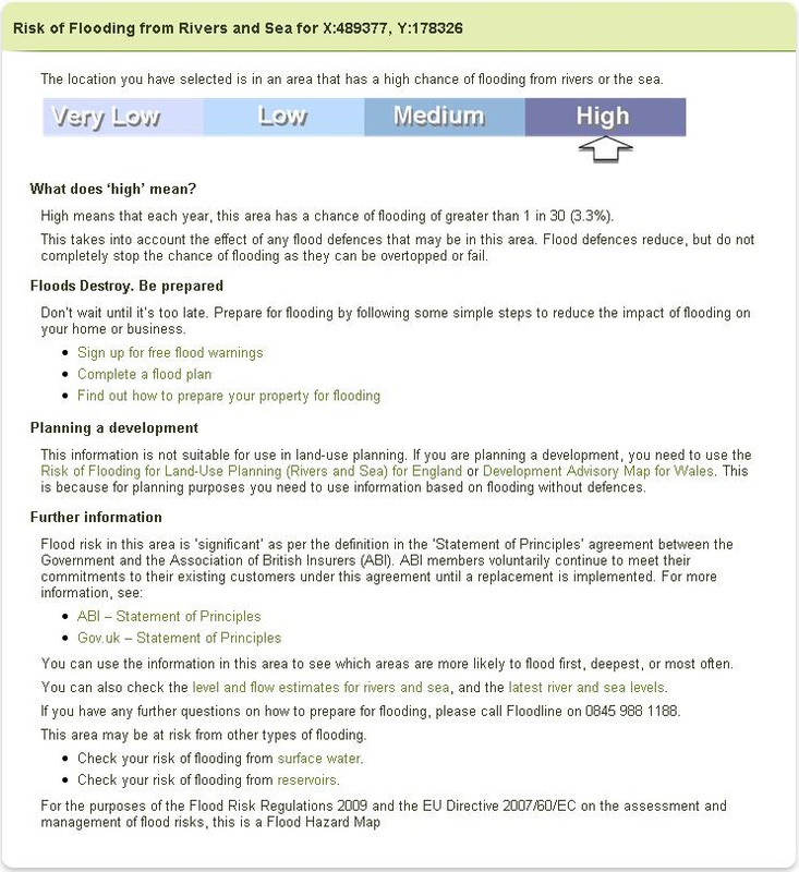
Your following link is intended for householders / insurers and general information, and I show a copy of it attached (HolyportAreaFlood.jpg);
http://watermaps.environment-agency.gov.uk/wiyby/wiyby.aspx?topic=floodmap#x=489392&y=178023&scale=9
In the note that one can access by clicking on the coloured areas giving a key to the terms High, Medium, and Low as follows;
http://watermaps.environment-agency.gov.uk/wiyby/WiybyMapQueryResults.aspx?lang=_e&scale=9&cx=489392&cy=178023&topic=floodmap&layerid=0&x=489779&y=178326
We see;
Flood risk in this area is ‘significant’ as per the definition in the ‘Statement of Principles’ agreement between the Government and the Association of British Insurers (ABI). ABI members voluntarily continue to meet their commitments to their existing customers under this agreement until a replacement is implemented. For more information, see:
ABI – Statement of Principles
Gov.uk – Statement of Principles
You can use the information in this area to see which areas are more likely to flood first, deepest, or most often.
You can also check the level and flow estimates for rivers and sea, and the latest river and sea levels.
If you have any further questions on how to prepare for flooding, please call Floodline on 0845 988 1188.
This area may be at risk from other types of flooding.
Check your risk of flooding from surface water.
Check your risk of flooding from reservoirs.
For the purposes of the Flood Risk Regulations 2009 and the EU Directive 2007/60/EC on the assessment and management of flood risks, this is a Flood Hazard Map.
And under the heading "Planning a development" we see that in England, Planners are to refer to "Risk of Flooding for Land-Use Planning (Rivers and Sea)", and we are advised that this is because for planning purposes "you need to use information based on flooding without defences."
(I show a link to that information below, but unfortunately although the previous two links work (for me) the next link does not but maybe it will work for you.)
http://maps.environment-agency.gov.uk/wiyby/wiybyController?value=SL6+2HA&submit.x=16&submit.y=12&submit=Search%09&lang=_e&ep=map&topic=floodmap&layerGroups=default&scale=9&textonly=on
However, I show a screen shot of it attached, (LesserRisk.jpg).
Comparing your two presentations we see that the Flood Risk you give to Planners based on flooding WITHOUT defences is LESS than that WITH flood defences.
Surely this cannot be correct, or am I missing something?
In the notes accompanying the map for planners we see as follows;
This map is for land-use planning. If you are planning a development, you will need to undertake a more detailed flood risk assessment to show how the flood risk to the site, or elsewhere as a result of proposed changes to the site, can be managed as part of your development proposal.
Local planning authorities should use this map alongside an up-to-date Strategic Flood Risk Assessment to:
* identify when a flood risk assessment is required
* identify when a consultation with the Environment Agency is needed
* apply the sequential test in the absence of a suitable Strategic Flood Risk Assessment Flood Zone definitions are set out in the National Planning Policy Guidance:
* Flood Zone 1 - land assessed as having a less than 1 in 1,000 annual probability of river or sea flooding (<0.1%)
* Flood Zone 2 - land assessed as having between a 1 in 100 and 1 in 1,000 annual probability of river flooding (1% – 0.1%), or between a 1 in 200 and 1 in 1,000 annual probability of sea flooding (0.5% – 0.1%) in any year
* Flood Zone 3 - land assessed as having a 1 in 100 or greater annual probability of river flooding (>1%), or a 1 in 200 or greater annual probability of flooding from the sea (>0.5%) in any year
Note: These flood zones refer to the probability of river and sea flooding, ignoring the presence of defences.
If you do not want information for planning purposes, but would like more information, you can also check your risk of flooding from:
Rivers and the sea
Reservoirs
Surface Water
Sincerely,
Andrew Cormie,
Chairman, Holyport Residents Association
The following was received in reply;
Subject: Re: Environment Agency Flood Maps
Dear Mr Cormie,
Further to your e-mail on the 7th of January 2014, regarding the flood mapping on our website.
The Flood Risk Mapping for planning purposes maps (Lesser Risk.jpg) in your e-mail provides a view of the flood zones produced either with detailed flood modelling or using our National Generalised flood modelling (JFLOW). These extents provide flood extents without any defences.
New detailed flood modelling has updated several sections of the River Cut without defences. However our National Flood Risk Assessment (NaFRA) which takes into account the condition, type and Standard of Protection of any defences in the area; is still required to be updated in this area.
The NaFRA is used to update the mapping within the “flood risk from rivers and the sea maps” (HolyportAreaFlood.jpg), which explains why there is a difference in the risk associated with this in comparison to the mapping for planning purposes. Our modelling programme means that we will be updating our flood risk from rivers and the sea maps in this area in our quarterly updates, with a new NaFRA rating within 6 months.
The new modelled flood water levels from the detailed flood modelling will be used to update our NaFRA risk rating for the area, whilst taking into account the condition, type and Standard of Protection of any defences in the area.
I hope that the above answers your questions, if you have any further queries please do not hesitate contact me.
Kind Regards,
Mike
Michael Piotrowski
FCRM Officer
Partnership and Strategic Overview Berkshire and Buckinghamshire Team,
South East Region
To which I replied;
Subject: RE: Environment Agency Flood Maps
Importance: High
Dear Mr Piotrowski,
Thanks for your email, from which I conclude that the Flood Risk Mapping for planning purposes (shown here as LesserRisk.jpg) is currently showing a lower risk than actual, even although shown as if defences were not in place, and when updated within 6 months will show a greater risk.
I also conclude that as the map for insurers and ordinary people (shown here as HolyportAreaFlood.jpg) presumably shows an accurate status, with the effect of defences actually in place; then the updated Flood Risk for Planning purposes, as if defences were not in place, will show a greater risk than the HolyportAreaFlood.jpg.
Please urgently confirm that I have understood correctly and if I have please agree with me that where your maps for Planning Purposes are showing a lesser risk than actual, the Environment Agency should urgently place on its website a warning notice to that effect, telling planners to meantime use the maps in the "flood risk from rivers and the sea" pages.
Regards,
Andrew Cormie,
Chairman, Holyport Residents Association
The following was the reply I received;
Dear Mr Cormie,
Thank you for your recent e-mail and apologies for my delayed response which is due to our ongoing flood incident.
I can confirm that you have understood incorrectly, the flood risk mapping for planning purposes is showing the correct flood outline for flood zone 3. This new flood outline which was updated in August 2013 shows the 1% AEP (1 in 100 year) flood event outline, which does not include any defences.
The flood risk from rivers and the sea maps include results that incorporate the crest height, the type and the Standard of Protection of any defences. However we have not yet updated these maps with new flood water levels from our detailed modelling. These flood water levels will be used to update our flood risk from rivers and the sea in 6 months (mid June 2014) and will provide an updated view of the flood risk, the new water levels are likely to alter the level of risk in this location.
We will not be placing a warning notice advising planners, as the current flood zones used for planning purposes are correct at this time. Please find attached a copy of the flood zones and the water levels associated with this. Our flood risk from the rivers and the sea will use these river levels to provide an update to the risk in this location as per my comments above.
If you have any further questions, please do not hesitate to contact me. I currently have intermittent access to my e-mails due to the ongoing incident, but will be available tomorrow afternoon.
Best Regards,
Michael
Michael Piotrowski
FCRM Officer
Partnership and Strategic Overview Berkshire and Buckinghamshire Team,
South East Region
The attachments referred to are shown below. I have not been able to muster the enthusiasm to pursue this further at this time, and confess to being still confused. It seems that the Environment Agency is telling us that the flood maps for planning are correct, but the maps for insurers and ordinary people are wrong and will be updated within six months.


